Why Is GMADA Mapping 4,000 Acres Near Chandigarh Airport? The Answer Could Change Mohali’s Future
Published by: News Desk | Garah Pravesh
Date: June 2026
Category: Mohali Real Estate News | GMADA Updates | Aerotropolis Development
Mohali Aerotropolis Set for a Massive Digital Transformation
A major development has emerged from Mohali’s rapidly expanding Aerotropolis region that could significantly influence future infrastructure planning, land utilization, property values, industrial growth, and investor confidence.
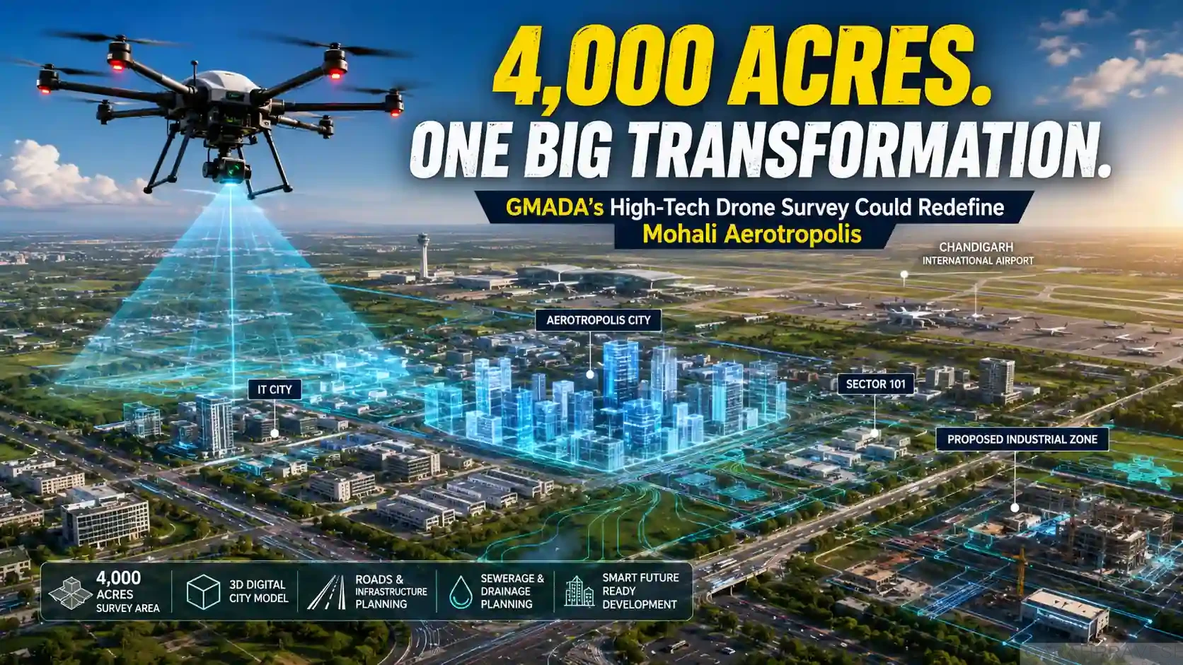
According to reports published in Mohali Bhaskar, the Greater Mohali Area Development Authority (GMADA) has initiated a large-scale high-tech drone survey covering approximately 4,000 acres of land around the Aerotropolis zone near Chandigarh International Airport. The project aims to create a comprehensive 3D digital model of Aerotropolis City within six months, enabling authorities to accurately plan roads, sewerage systems, drainage networks, water supply lines, industrial zones, residential sectors, and future urban expansion.
For property buyers, investors, developers, industrial stakeholders, and NRIs tracking Mohali’s growth story, this is one of the most significant infrastructure planning announcements of 2026.
Why This News Matters More Than Most People Realize
Most people see drone surveys as technical government exercises.
In reality, such projects often become the foundation for future city planning decisions that can influence property prices, infrastructure spending, commercial growth corridors, and investment demand for years.
The Aerotropolis region is already emerging as one of Punjab’s most ambitious urban development zones. A detailed digital survey of thousands of acres indicates that authorities are preparing for a more systematic and technology-driven phase of development.
When infrastructure planning becomes data-driven, future projects typically face fewer execution delays, fewer alignment disputes, better drainage management, more efficient road connectivity, and improved utility planning.
For real estate investors, these factors directly affect long-term appreciation potential.
What Exactly Is GMADA Planning?
A High-Tech Drone Survey Across 4,000 Acres
GMADA has reportedly commissioned a drone-based mapping project covering approximately 4,000 acres surrounding the Aerotropolis development area.
The survey will use advanced aerial mapping technology to create:
- High-resolution topographical maps
- Digital elevation models
- Accurate land contour mapping
- Existing road network mapping
- Sewerage and drainage assessment
- Utility corridor identification
- Water flow analysis
- Geographic Information System (GIS) datasets
- Three-dimensional city models
Unlike conventional surveys, drone technology can capture millions of data points within a relatively short time, producing highly accurate digital representations of the terrain.
Estimated Project Cost
According to the report, the drone survey project is expected to cost approximately ₹17 lakh.
While the cost appears modest compared to the scale of development, the long-term value lies in generating precise data that can support infrastructure investments worth hundreds or even thousands of crores in the future.
Timeline
GMADA officials have indicated that the project is expected to be completed within approximately six months.
Once completed, authorities will have access to a detailed digital model of Aerotropolis City and surrounding sectors.
Understanding the Scale: What Is Included in the Survey Area?
The survey reportedly covers:
Aerotropolis City
The flagship development zone surrounding Chandigarh International Airport.
IT City
One of Mohali’s most important technology and business destinations attracting IT companies, startups, and commercial investments.
Sector 101
A rapidly developing area receiving increasing attention from investors and developers.
Proposed Industrial Areas
The project reportedly includes mapping of future industrial expansion corridors that could play a major role in employment generation and economic growth.
The Big Objective: Building a Complete 3D Digital Twin of Aerotropolis
One of the most interesting aspects of this initiative is the creation of a comprehensive 3D city model.
Urban planners worldwide increasingly use digital twins to simulate city infrastructure before actual construction begins.
Such models help authorities:
Predict Water Flow
Stormwater movement can be analyzed before roads and buildings are developed.
Improve Sewerage Planning
Future sewer lines can be designed based on actual terrain conditions.
Optimize Road Networks
Road alignments can be planned with greater precision.
Reduce Future Infrastructure Errors
Mistakes that normally surface after construction can be identified earlier.
Improve Utility Distribution
Water pipelines, electrical infrastructure, telecom networks, and gas lines can be planned more efficiently.
How Will This Impact Property Buyers?
Better Infrastructure Usually Supports Higher Demand
One of the biggest concerns among property buyers is whether promised infrastructure will actually be delivered.
A detailed survey provides authorities with accurate information required for implementation.
Historically, areas with better planning often attract:
- Higher residential demand
- Improved commercial activity
- Better rental prospects
- Faster infrastructure execution
- Increased developer interest
While no appreciation is guaranteed, infrastructure-led growth remains one of the strongest drivers of real estate value creation.
Impact on Commercial Property Investors
The Aerotropolis region has already emerged as a hotspot for:
- Showrooms
- Retail spaces
- SCO investments
- Commercial plots
- Office developments
- Mixed-use projects
Improved planning can create greater certainty for future infrastructure deployment.
For investors evaluating opportunities along:
- PR7 Airport Road
- Aerocity
- Aerotropolis
- IT City
- Sector 101
- Airport growth corridor
this development adds another positive indicator supporting long-term growth prospects.
Why Drainage Planning Is Becoming a Major Focus
Many Indian urban centers face infrastructure challenges because drainage planning occurs after substantial development has already taken place.
GMADA’s approach appears to focus on understanding:
- Natural water flow patterns
- Existing drainage conditions
- Future sewerage requirements
- Rainwater accumulation zones
This proactive planning could help avoid costly infrastructure corrections later.
The Strategic Importance of Aerotropolis Mohali
Airport-Led Urban Development
Globally, cities located around major airports often become economic growth hubs.
Examples include:
- Dubai Airport Zone
- Hyderabad Airport Corridor
- Bengaluru Airport Region
- Delhi Aerocity
Mohali’s Aerotropolis is being positioned around similar principles.
The presence of Chandigarh International Airport creates opportunities for:
- Logistics
- Warehousing
- Hospitality
- IT Services
- Corporate Offices
- Retail Development
- Industrial Expansion
Aerotropolis vs Traditional Urban Expansion
Traditional city growth often occurs in fragmented phases.
Aerotropolis planning follows a more integrated approach.
Key advantages include:
Planned Infrastructure
Roads and utilities are designed before dense development occurs.
Economic Clustering
Businesses benefit from proximity to transport hubs.
Better Connectivity
Airport access becomes a major value driver.
Future Scalability
Growth can be managed more effectively.
What This Means for PR7 Airport Road Investors
PR7 Airport Road remains one of the most closely watched corridors in Tricity real estate.
Several factors already support its investment appeal:
- Airport connectivity
- Expanding residential catchment
- Commercial development activity
- Future industrial growth
- Government-backed infrastructure projects
The latest drone survey announcement strengthens the narrative that authorities continue investing in systematic development across the region.
Industrial Development Could Be the Hidden Catalyst
The report also references planning related to industrial expansion.
Industrial growth often creates:
- Employment opportunities
- Residential demand
- Rental demand
- Commercial demand
- Service sector growth
Many successful real estate corridors experience appreciation only after employment centers begin attracting workforce populations.
If industrial development progresses alongside Aerotropolis expansion, the region could witness broader economic activity.
What Experts Are Watching Next
Several developments will likely be monitored closely over the coming months:
Completion of Drone Survey
The first milestone will be successful completion of mapping activities.
Release of Planning Insights
Stakeholders will be interested in any planning outcomes derived from the survey.
Infrastructure Tender Announcements
Future road, sewerage, and utility tenders could provide further indications of implementation timelines.
Industrial Area Progress
Announcements related to industrial development may become important growth indicators.
Mohali Aerotropolis Expansion Updates
Any future sector launches or infrastructure projects will attract market attention.
Real Estate Market Outlook for Mohali Aerotropolis
As of mid-2026, Mohali continues to benefit from several structural advantages:
Strategic Airport Location
Connectivity remains a major demand driver.
Government-Led Infrastructure Spending
Ongoing development projects continue supporting growth.
Expanding Commercial Activity
New business and retail developments are increasing economic activity.
Investor Interest
Both local and NRI investors continue monitoring the region closely.
Long-Term Urban Planning
The drone survey demonstrates a technology-driven planning approach that may support future development efficiency.
Editorial Analysis: Why This Development Deserves Attention
Not every government announcement has long-term implications.
This one does.
A 4,000-acre drone survey may appear administrative on the surface, but it represents something larger: a transition toward data-driven urban planning.
Cities that invest in accurate planning data before large-scale development generally reduce costly mistakes later.
For Aerotropolis, IT City, Sector 101, and the wider PR7 Airport Road region, the project signals continued institutional focus on creating a structured urban ecosystem rather than fragmented expansion.
Investors should avoid speculative assumptions, but they should also recognize that infrastructure planning often precedes major development cycles.
Frequently Asked Questions (FAQ)
Is GMADA conducting a drone survey in Mohali Aerotropolis?
Yes. Reports indicate that GMADA has initiated a high-tech drone survey covering approximately 4,000 acres around Mohali Aerotropolis and surrounding development zones.
What is the purpose of the drone survey?
The primary objective is to create detailed digital maps and a 3D model to support future planning of roads, drainage systems, sewerage networks, utilities, and urban infrastructure.
How much will the project cost?
The reported cost of the drone survey project is approximately ₹17 lakh.
How long will the survey take?
Officials have indicated an estimated completion timeline of around six months.
Which areas are included?
The survey reportedly covers Mohali Aerotropolis, IT City, Sector 101, and nearby proposed industrial development zones.
Will this increase property prices?
No direct increase is guaranteed. However, improved infrastructure planning often supports stronger long-term demand and development potential.
Why is Mohali Aerotropolis important?
Its proximity to Chandigarh International Airport positions it as a strategic location for residential, commercial, logistics, hospitality, and industrial growth.
#MohaliNews #AerotropolisMohali #GMADA #PR7AirportRoad #PropertyInvestment #MohaliRealEstate #ITCityMohali #Sector101Mohali #ChandigarhAirport #CommercialProperty #PunjabInfrastructure #RealEstateNews #TricityProperty #AerocityMohali #InvestmentNews
Disclaimer: This article is based on publicly available news reports and information available at the time of publication. The content is intended solely for informational and educational purposes and should not be interpreted as investment, legal, financial, planning, or regulatory advice. Infrastructure projects, government policies, timelines, land-use plans, approvals, and development proposals may change without prior notice. Readers are strongly advised to verify all information through official GMADA notifications, government publications, and relevant authorities before making any property purchase, investment, or business decision. The publisher, author, and Garah Pravesh assume no liability for losses, damages, decisions, or actions taken based on the information presented in this article. Independent due diligence is essential before entering into any real estate transaction.